|
The Ancient Egyptian Geography - Developing the Nile Civilization
How did the ancient Egyptian geography mold one of the earliest civilizations in the world? Read on to find out how it affected the lives and culture of the ancient Egyptians. The Making of a Thriving CityLooking at its map, you will see that Egyptians built most of its cities near the Nile River. Cities must have constant access to the nearest water source for its population. Add to the need for transportation and an artery for trade, the Nile River perfectly does its job well. If you go on land, with no roads built and aids for transport, carrying goods means delaying the services. To drive this point home, Egyptians even used the river to bring heavy stones from one place to another. The Nile River also feed the Egyptians through vegetation. After the annual flooding subsides, it leaves a black trail of silt in the valley, ready to be used! It quickly developed ancient Egypt into an agricultural powerhouse. In addition to that, they also get food from the Nile River such as fishes and eels. Even animals and wildlife go to the nearest water supply. This means more food for the population and at the same time, more food for the crocodiles! Feeding themselves in the middle of the desert has never been this easy!
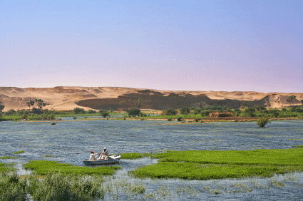
A beautiful scene of the Nile River and the Sahara Desert Geography and the Roots of ReligionThe geographic conditions in ancient Egypt showed the kind of gods they worshiped. They have the Egyptian sun god, and gods directly affecting their environment. Without something to worship about, they are struck with problems such as famine and the extended flooding of the river. The ancient Egyptian geography revolutionized the development of their religion. The Reeds of PaperPapyrus reeds that grow naturally in the swamp river delta give Egyptians another option to take advantage for. They use this for fuel, making mats and best of all, for paper! They used it as an earliest form of paper for recording important events. However, don't take it for granted. The paper can survive for many years because it’s durable, thin, and light. Protecting a CivilizationThe geography of ancient Egypt also includes natural barriers to protect it from their enemies. One of them is the Sahara Desert. Of course, no one would risk their army in a journey of dehydration before the battle even begins! They also have the Mediterranean Sea, which protected them from the North. The Nile River also posed another barrier because if you attempted to enter Egypt through the delta on the north, you will row upstream! With all of those things mentioned above, it kept the safety of ancient Egypt. The geography of it has huge impacts on this civilization. On the other hand, other ancient nations envy it because it has all the necessary tools for development. If you studied the ancient Egyptian geography in more detail, you would find a diamond in the sand! Return To... Return from Ancient Egyptian Geography to Home Page
|
